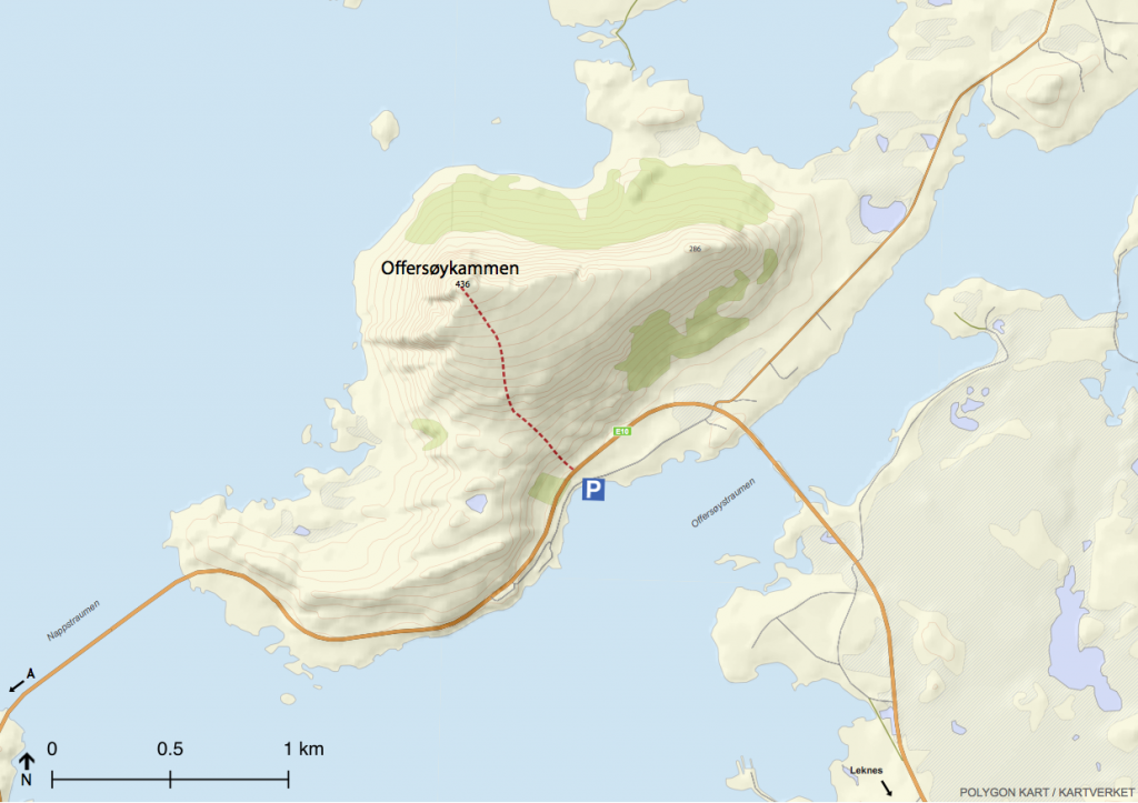
lofoten-hiking

KVALVIKA

MOH: 170 / 543
Difficulty: 2 / 4
Duration: 1-3 hours one way


After Ramberg walking towards Å, follow signs towards Fredvang. The trip to

Kvalvika starts at the car park at Torsfjorden. From here the trail continues northward,

up the hillside, along the moraine and mire terrain, before the descent to Kvalvika

begins. The path is apparent. To go up to Ryten which has great views down to

Kvalvika, the trail starts east in Kvalvika and follows the brook up to Forsvatnet.

After passing the water, the trail goes east along the ridge towards the top of Ryten.

Posted by lofoten-hiking in Ukategorisert, 0 comments

DJEVELPORTEN

MOH: 426
Difficulty: 3 / 4
Duration: 1,5 hour one way


Posted by lofoten-hiking in Ukategorisert, 0 comments

OFFERSØYKAMMEN

MAS: 436
Difficulty: 2 / 4
Duration: 1  hour one way

Follow E10 towards Å from Leknes. After Offersøybrua, turn towards Skreda. After 600 meters you will come to a parking lot at a small green where you can park. From here the trail continues in a northerly direction, over the E10 and continues up the mountain. The path is clear and easy to follow all the way to the top.

kart


Posted by lofoten-hiking in Vestvågøy, 0 comments

EGGUM – UNSTAD

Difficulty: 2 / 4
Duration: 2 hours one way

Eggum – Unstad is great to walk in the midnight sun. One can also make the trip from Unstad to Eggum. From Eggum follow the old dirt road, which will eventually join a trail. The trail follows the coastal strip, before later going further up the hillside. The trip may at some places be steep and slippery in wet weather, especially on the rocky sections.


Posted by lofoten-hiking in Vestvågøy, 0 comments

Best hikes from Svolvær – EN

Svolvær is the biggest town in Lofoten with 4500 residents and the base for many tourists visiting Lofoten. Svolvær offers a great variety of accommodations, restaurants and hikes. Surrounded by mountains on the east, north and west side of the town Svolvær is the base for many great hikes and viewpoints.

1. Tjeldbergtind

_MG_9385

Tjeldbergtind is a easy and short hike with great views, close to the road. This makes this mountain very popular among locals and tourists. Read more…

2. Geita / Djevelporten / Fløya

geita

Hiking towards Geita, Djevelporten or Fløya offers great views. The hike is some steep and some parts are windy. Read more…

3. Tuva

Skjermbilde 2016-07-21 kl. 23.26.37

Tuva is a great viewpoint. On the way you will walk side by side with rivers and lakes. The path is well trodden. Read more…


Posted by lofoten-hiking in Vågan, 0 comments

TUVA

MOH: 477
Difficulty: 2 / 4
Duration: 2 hours one way


The trail to Tuva starts near the campsite Lofoten Feriesenter and the Red Cross house. Here it is possible to park (see parking on the map under).  From the parking, follow the gravel road going north, which will turn in to a path. Follow the path in the direction of Grønnåsen, and walk on the side of the lake. After the lake, follow the path side by side the river towards the top. The last part going to the top is windy, but offers great views.


Posted by lofoten-hiking in Vågan, 0 comments

JUSTADTIND

MOS: 738
Difficulty: 3 / 4
Duration: 2-3 hours one way


Justadtind offers a great view towards Henningsvær, Vestfjorden and the surrounding mountains.
The walk starts at Hagskaret, the hig- hest point (130 mas) between Leknes and Stamsund. A big parking lot is loca- ted close to the road in north west dire- ction. From here you can follow the trail or the gravel road north west from the parking lot, passing a telephone mast 100 meters up the road. Right before the end of the road, you will nd a trail leading to Karsteinheia and Steinheia. Follow the trail from Steinheia, downhill and across the marshland. Follow the trail on the ridge towards the top.

justadtind_kart


Posted by lofoten-hiking in Ukategorisert, 0 comments

HOVEN

MOH: 368
Difficulty: 1 / 4
Duration: 1 hour one way


Hoven is a great trip to combine with the midnight sun. It is also a good vantage point

with views to Austvågøy and Vestvågøy. The walk starts at the golf course parking

lot, firstly going over flat marsh before going up the back of the mountain. The path is

well trodden and is easy to find.


Posted by lofoten-hiking in Vågan, 0 comments